How do Drones Help Project Managers?
and Site Engineers, Schedulers, Estimators, Contract Administrators, Stock Controllers, Safety Advisors, Mining Engineers, Rehabilitation Officers, Quarry Supervisors, Environmental Officers, Production Superintendents
- Certified Drone Operator -
See More - Manage More - With Drones
- RePL - AROC - REOC -
Project Managers' Responsibilities
Construction Projects have allocated Project Managers who are ultimately responsible for delivery of the project on time and on budget. Drones are the new tool in the tool-box of streamlining project delivery. Project Managers can benefit from the use of drones in the following ways:
Capital Expenditure and Operational Expenditure Justification
Capital Expenditure Proposals – most significant construction projects start with a funding proposal and justification as to why the business needs the project to proceed. Drone imagery of the vacant lot or site allows those less familiar with the area, a greater ability to visualise the project. If a preliminary design has been completed, an overlay of the design can be applied. For brown-field sites, showing the existing infrastructure and new project site as a whole, provides clients and ‘approvers’ with improved visualisation, meaning a greater understanding and benefits of the project.
Pre-Feasibility, Concept Design and Layout
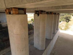
Design, Planning and Layout – every construction project has a design phase. Providing engineers and architects with aerial images benefits the design process by allowing the visualisation of today’s conditions (rather than a Google map that could be six years old). It may be pertinent to assess the area directly surrounding the site to determine if the project will impact the local area; for example, a nearby property could be impacted by lighting on the building, an alternative may be to light from the boundary towards the building.
Drones can be used to quickly demonstrate the height of a building or structure. Where sight lines are important, the drone can be positioned at a structures’ corner or apex to determine visibility. Simply raising the drone up or down, the pilot can determine the visibility (or obscured) position of the structure by use of the drones’ altimeter. Communications can be critical to many projects where line-of-site is required (e.g. microwave link) with a neighbouring tower or building. The drone can be positioned at the design height and location of the proposed communications asset, where an assessment of the adjacent towers’ visibility can be determined.
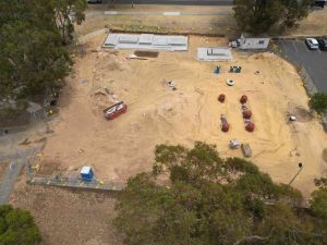
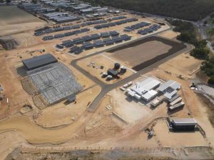
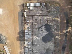
Project Tracking and Reporting
Project Tracking – monitoring projects closely provides the earliest notice when events are deviating from the plan or schedule. The earlier the detection, the lower cost of rectification and smallest interruption to the project schedule. Drones aid in the monitoring of projects by providing a birds-eye view of the works to provide simultaneous context of different parts of the project. For example; being able to see in one photo or map that the, 1) materials are available, 2) road access is in place and 3) formwork is completed, provides a clear confirmation of the readiness for the next stage.
Repeatable, Predictable Data Capture
Automated Flights – having a repeatable flight path ensures every section of the project is captured the same way each flight. The same 20, 200 or even 2000 photos ensures a constant coverage of the selected project areas. Dedicated Way Points can be utilised to capture specific photos or videos at defined locations, heights and angles. By using Missions with automated flights or specific Way Points, this reduces flight time on site, particularly useful when a flight is scheduled for when personnel are not in the area (i.e. during a lunch break or after hours).
Save Travel Time and Cost
Remote Projects – where a Project Manager is unable to regularly attend site in person, a drone Pilot can fly the site and save the PM valuable time. Even a project site that is relatively close can easily consume half a day to drive to, drive around the site, discuss, take photos and notes, then drive back and upload any photos. Outsourcing this, when needed, enables the PM to obtain a clear understanding of the project progress whilst saving time. After all, the Execution Phase of a project is the busiest and most time sensitive phase of a construction project. Delays and missed errors are very costly at this stage, however, early detection can minimise cost and time impacts on the project.
Contractors Situational Awareness Improves
Communication – Communication – Communication – Many contractors and subcontractors can be on site at the same time. Situations easily arise where there is conflict, such as two parties wanting to be in the same location at the same time. Safety or simple logistics may dictate that the works cannot occur concurrently. It may be that one contractor has spread their workers to all areas, leaving another contractor without access, resulting in the second contractor losing time and money. A work site dispute can easily commence, resulting in diminished productivity of the working contractor, plus the second contractor has zero productivity. Avoid this with proactive, engaging and clear communications.
Engagement of Contractors Improves
How do you make communications clearer and more engaging? By providing “live” drone photography of the project in progress. Photos prompt more discussion and more clearly demonstrate what is actually happening on site. In our example above, the drone photos (or 2D map) indicate that contractor A had pre-placed materials at all 5 sections of the site. Contractor B, seeing this at a progress meeting, made an enquiry and identified that Contractor A was intending to commence at all 5 sections together. Contractor A and B, together with the Project Manager, determined that Contractor A would be better to focus their personnel in the one or two areas leaving the other areas available for Contractor B. The visualisation of the materials allows other parties to query the likely next events on site and plan accordingly.
Single Source of Truth - Photos Don't Lie
Creating a single-source-of-truth – aerial imagery – available to all parties throughout the project will empower each member of the team to communicate with the use of the photos. Just like Project Managers and Contractors alike communicate with construction drawings on what it should look like (future), photos provide the ability to communicate with what it does look like (present). Communications are more effective with pictures (drawings or photos), so drones fill the gap of having current photos, ready for the team to use at a moment’s notice.
Communicate Effectively with Key Stakeholders
Project Reporting, Documentation and Close Out – Project Managers will, throughout the project, be asked to document the progress of a project to the Project Sponsor, stakeholders, CEO, Board or other Department Managers. Aerial images and video support the updating of Gantt Charts, monthly progress reports, Inspection and Test Plans and financial expenditure reports. Whilst a single ground based image of some steel work or the latest concrete culvert may not translate easily to progress, an aerial image can provide real visual context that the project is say “60% complete”. Utilising these images in reports and presentations, provides more context, where a-picture-is-1000-words has never been truer for an aerial photo.